  |
 |
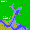
Lake Merritt was not always a lake. Before the 1870's, it was an arm of the San Francisco Bay.Oakland Mayor Dr. Samual Merritt dontated the money in 1869 to begin building a dam at the 12th Street bridge, across the "neck" of the inlet, in order to make a lake for Oakland. The lake he created was called "Merritt's Lake" by people for many years, and gradually became Lake Merritt.
![[Lake Merritt, 1857 Map]](images/lake53.jpg) Larger version of map (500 x 500, 35 KB) available.
|
![[Lake Merritt, 1998 Map]](images/lake98.jpg) Larger version of map (499 x 498, 33 KB) available.
|

|
An animation of the shoreline as it changed
from 1857 to 1998 is also available. |
The creation of Lake Merritt is not the only major change to Oakland's bayshore. Around 1900, the peninsula of land connecting Oakland with the Alameda Peninsula was cut through, to provide a connection for boats from San Leandro Bay to the San Antonio Estuary, where Oakland's harbor is.In many other places, mud flats and bay had been filled in, to extend Oakland's shore (and Alameda's) well into the bay.
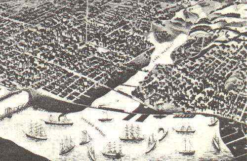
Lake Merritt in 1882. The lake has been dammed, but most of the "neck" leading to the bay has not been filled in yet. Note the large number of sailing ships.