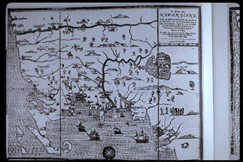
A Map of New England. 1677.

A Map of New England. Woodcut by John Foster, Boston, 1677.
The legend on this
woodcut map describes it as "the first that ever was here cut, and done by the
best Pattern, that could be had, which being in some places defective, it made the
other less exact: yet doth it sufficiently shew the Scituation of the Country,
and conveniently well the distances of Places." No earlier printed map has ever
been identified, and the engraver's claim to be responsible for the first
cartographical production in wood or copper in what is now the United States
still holds. The map was issued in William Hubbard's The present State of
New-England,
being a Narrative of the Troubles with the Indians, which was printed
and published by Foster in Boston in 1677. The engraver did not sign the map but
it has long been accepted as Foster's work. West is represented at the top of the
map and east at the bottom, showing Cape Cod at the lower left, and Rhode Island
literally as an island.